
Mapa topográfico Bahamas
Mapa interativo
Clique no mapa para exibir a altitude.
Sobre este mapa
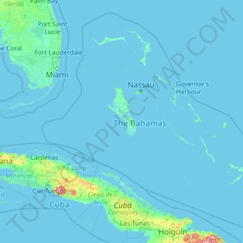
Nome: Mapa topográfico Bahamas, altitude, relevo.
Local: Bahamas (20.70598 -80.70019 27.47346 -72.44775)
Altitude média: 9 m
Altitude mínima: -4 m
Altitude máxima: 1111 m
According to the Köppen climate classification, the climate of The Bahamas is mostly tropical savannah climate or Aw, with a hot and wet season and a warm and dry season. The low latitude, warm tropical Gulf Stream, and low elevation give The Bahamas a warm and winterless climate.
Outros mapas topográficos
Clique em um mapa para visualizar sua topografia, sua altitude e seu relevo.
Great Stirrup Cay
Great Stirrup Cay, Berry Islands, Bahamas
Altitude média: 1 m
Marsh Harbour
Bahamas > Marsh Harbour > Marsh Harbour
Marsh Harbour, AB20087, Bahamas
Altitude média: 2 m