
Mapa topográfico Peachtree City
Mapa interativo
Clique no mapa para exibir a altitude.
Sobre este mapa
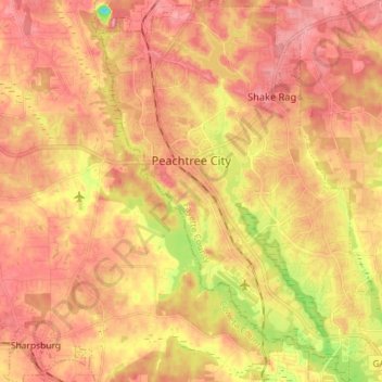
Nome: Mapa topográfico Peachtree City, altitude, relevo.
Altitude média: 262 m
Altitude mínima: 180 m
Altitude máxima: 309 m
Shakerag Hill, with an elevation of 980 feet (300 m), is the highest point in the city and sits on the eastern border at the intersection of GA Hwy 54 and Robinson Road.
Outros mapas topográficos
Clique em um mapa para visualizar sua topografia, sua altitude e seu relevo.
Huntington Place
United States > Georgia > Fayette County > Peachtree City
Huntington Place, Peachtree City, Fayette County, Georgia, 30269, United States
Altitude média: 249 m
Fayetteville
United States > Georgia > Fayette County
Fayetteville, Fayette County, Georgia, United States
Altitude média: 265 m
Tamerlane
United States > Georgia > Fayette County > Peachtree City > Tamerlane
Tamerlane, Peachtree City, Fayette County, Georgia, 30269, United States
Altitude média: 247 m