
Mapa topográfico Mitchell
Mapa interativo
Clique no mapa para exibir a altitude.
Sobre este mapa
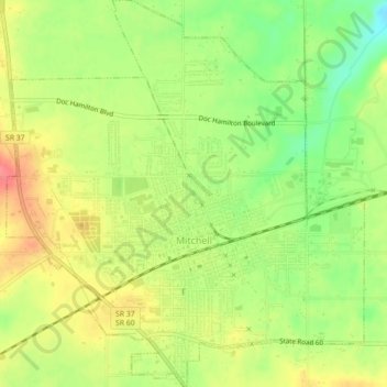
Nome: Mapa topográfico Mitchell, altitude, relevo.
Local: Mitchell, Lawrence County, Indiana, 47446, United States (38.71975 -86.49511 38.75428 -86.45410)
Altitude média: 209 m
Altitude mínima: 174 m
Altitude máxima: 242 m
Outros mapas topográficos
Clique em um mapa para visualizar sua topografia, sua altitude e seu relevo.
Otis Park
United States > Indiana > Lawrence County > Bedford
Otis Park, Bedford, Lawrence County, Indiana, United States
Altitude média: 186 m
Bedford
United States > Indiana > Lawrence County
Bedford, Lawrence County, Indiana, 47421, United States
Altitude média: 191 m
Rabbitville
United States > Indiana > Lawrence County
Rabbitville, Lawrence County, Indiana, 47446, United States
Altitude média: 196 m
Crawford
United States > Indiana > Lawrence County > Crawford
Crawford, Lawrence County, Indiana, United States
Altitude média: 198 m
Springville
United States > Indiana > Lawrence County > Springville
Springville, Lawrence County, Indiana, United States
Altitude média: 219 m