
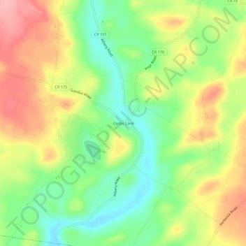
Mapa topográfico Cedar Lake
Mapa interativo
Clique no mapa para exibir a altitude.
Sobre este mapa
Nome: Mapa topográfico Cedar Lake, altitude, relevo.
Altitude média: 440 m
Altitude mínima: 384 m
Altitude máxima: 503 m
Outros mapas topográficos
Clique em um mapa para visualizar sua topografia, sua altitude e seu relevo.
Days Corners
United States > New York > Herkimer County > Town of Litchfield
Days Corners, Town of Litchfield, Herkimer County, New York, 13322, United States
Altitude média: 442 m
Norwich Corners
United States > New York > Herkimer County > Town of Litchfield
Norwich Corners, Town of Litchfield, Herkimer County, New York, 13456, United States
Altitude média: 385 m
Cranes Corners
United States > New York > Herkimer County > Town of Litchfield
Cranes Corners, Town of Litchfield, Herkimer County, New York, United States
Altitude média: 421 m