Geolocalizar

Mapa topográfico Hoogste Punt van Nederland

Mapa interativo

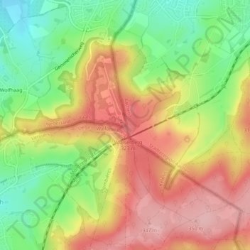
Clique no mapa para exibir a altitude.

Sobre este mapa

Nome: Mapa topográfico Hoogste Punt van Nederland, altitude, relevo.

Local: Hoogste Punt van Nederland, Vaals, Limburg, Nederland, 6291 BX, Nederland (50.75464 6.02071 50.75474 6.02081)

Altitude média: 272 m

Altitude mínima: 190 m

Altitude máxima: 347 m

Outros mapas topográficos

Clique em um mapa para visualizar sua topografia, sua altitude e seu relevo.

Raren

Nederland > Limburg > Vaals

Raren, Vaals, Limburg, Nederland, 6291 NN, Nederland

Altitude média: 222 m

Lemiers

Nederland > Limburg > Vaals

Lemiers, Vaals, Limburg, Nederland

Altitude média: 192 m

Wolfhaag

Nederland > Limburg > Vaals

Wolfhaag, Vaals, Limburg, Nederland, 6291 NB, Nederland

Altitude média: 237 m

Kasteel Vaalsbroek

Nederland > Limburg > Vaals

Kasteel Vaalsbroek, Vaalsbroek, Vaals, Limburg, Nederland, 6291NH, Nederland

Altitude média: 219 m