
Mapa topográfico Ostrand der Arendseer Hochfläche
Mapa interativo
Clique no mapa para exibir a altitude.
Sobre este mapa
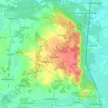
Nome: Mapa topográfico Ostrand der Arendseer Hochfläche, altitude, relevo.
Altitude média: 35 m
Altitude mínima: 18 m
Altitude máxima: 74 m
Outros mapas topográficos
Clique em um mapa para visualizar sua topografia, sua altitude e seu relevo.
Krevese
Deutschland > Sachsen-Anhalt > Osterburg (Altmark) > Krevese
Krevese, Osterburg (Altmark), Stendal, Sachsen-Anhalt, Deutschland
Altitude média: 47 m
Dequede
Deutschland > Sachsen-Anhalt > Osterburg (Altmark) > Krevese
Dequede, Krevese, Osterburg (Altmark), Stendal, Sachsen-Anhalt, Deutschland
Altitude média: 59 m