
Mapa topográfico Mörel-Filet
Mapa interativo
Clique no mapa para exibir a altitude.
Sobre este mapa
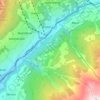
Nome: Mapa topográfico Mörel-Filet, altitude, relevo.
Local: Mörel-Filet, Östlich Raron, Wallis, 3983, Switzerland (46.32583 8.02700 46.37278 8.09274)
Altitude média: 1350 m
Altitude mínima: 694 m
Altitude máxima: 2904 m
Outros mapas topográficos
Clique em um mapa para visualizar sua topografia, sua altitude e seu relevo.
Mörel
Switzerland > Wallis > Östlich Raron > Mörel-Filet
Mörel, Mörel-Filet, Östlich Raron, Wallis, 3983, Switzerland
Altitude média: 1244 m
Binntal
Switzerland > Wallis > Östlich Raron > Grengiols
Binntal, Grengiols, Östlich Raron, Wallis, 3993, Switzerland
Altitude média: 2019 m