
Mapa topográfico Brenner Pass
Mapa interativo
Clique no mapa para exibir a altitude.
Brenner Pass
The Brenner Pass (German: Brennerpass [ˈbʁɛnɐpas], shortly Brenner; Italian: Passo del Brennero [ˈpasso del ˈbrɛnnero]) is a mountain pass over the Alps which forms the border between Italy and Austria. It is one of the principal passes of the Eastern Alpine range and has the lowest altitude among Alpine passes of the area.
Sobre este mapa
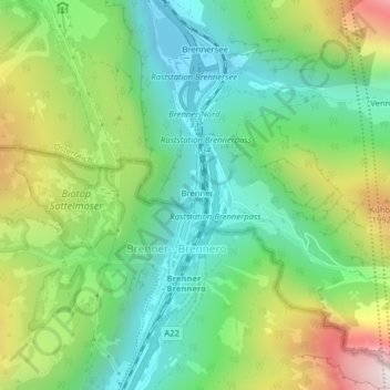
Nome: Mapa topográfico Brenner Pass, altitude, relevo.
Altitude média: 1635 m
Altitude mínima: 1309 m
Altitude máxima: 2252 m