
Mapa topográfico Worcester
Mapa interativo
Clique no mapa para exibir a altitude.
Sobre este mapa
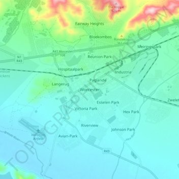
Nome: Mapa topográfico Worcester, altitude, relevo.
Altitude média: 252 m
Altitude mínima: 195 m
Altitude máxima: 525 m
Worcester is located at an elevation of 220 metres (720 ft) and can be reached by road either travelling on the N1 highway through the Huguenot Tunnel or by driving through spectacular mountain passes. From Cape Town Du Toitskloof, from Wellington Bainskloof, from Malmesbury, Western Cape Nieuwekloof, from Ceres Mitchells, from Robertson Goree, from Hermanus Rooihoogte and from Johannesburg Hex River, with vistas over the Hex River Valley.
Outros mapas topográficos
Clique em um mapa para visualizar sua topografia, sua altitude e seu relevo.
Baboon Peak
South Africa > Western Cape > Cape Winelands District Municipality > Breede Valley Local Municipality
Baboon Peak, Breede Valley Local Municipality, Cape Winelands District Municipality, Western Cape, South Africa
Altitude média: 1130 m
Du Toit's Peak
South Africa > Western Cape > Cape Winelands District Municipality > Breede Valley Local Municipality
Du Toit's Peak, Breede Valley Local Municipality, Cape Winelands District Municipality, Western Cape, South Africa
Altitude média: 1557 m