
Mapa topográfico Newbury
Mapa interativo
Clique no mapa para exibir a altitude.
Sobre este mapa
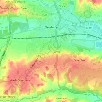
Nome: Mapa topográfico Newbury, altitude, relevo.
Local: Newbury, West Berkshire, England, United Kingdom (51.36711 -1.35315 51.41456 -1.28819)
Altitude média: 97 m
Altitude mínima: 64 m
Altitude máxima: 135 m
Elevations vary from a minimum of 72 m above mean sea level to 122 m at Wash Common. Elevations reach 150–200 m in the directly adjoining hills. The River Kennet and the Kennet and Avon Canal flow east through the centre of the town to reach the Thames at Reading, while the River Lambourn (beside which is the country's largest horse-training paddocks in the Valley of the Lambourn Downs) partly forms its northern boundary, ending in the town. A tributary that is smaller still, the River Enborne, forms the southern boundary (and also the county boundary with Hampshire).
Outros mapas topográficos
Clique em um mapa para visualizar sua topografia, sua altitude e seu relevo.
Welford
United Kingdom > England > West Berkshire
Welford, West Berkshire, England, United Kingdom
Altitude média: 124 m
Great Shefford
United Kingdom > England > West Berkshire
Great Shefford, West Berkshire, England, United Kingdom
Altitude média: 148 m
Bradfield
United Kingdom > England > West Berkshire
Bradfield, West Berkshire, England, United Kingdom
Altitude média: 77 m
Shaw
United Kingdom > England > West Berkshire
Shaw, West Berkshire, England, RG14 2DF, United Kingdom
Altitude média: 93 m
Hungerford
United Kingdom > England > West Berkshire
Hungerford, West Berkshire, England, United Kingdom
Altitude média: 131 m
Mortimer
United Kingdom > England > West Berkshire > Mortimer
Mortimer, West Berkshire, South East England, England, RG7 3RD, United Kingdom
Altitude média: 80 m
Reading
United Kingdom > England > West Berkshire > Reading
Reading, West Berkshire, South East England, England, RG1 1DA, United Kingdom
Altitude média: 56 m
Burghfield
United Kingdom > England > West Berkshire > Burghfield
Burghfield, West Berkshire, England, United Kingdom
Altitude média: 53 m
Brightwalton
United Kingdom > England > West Berkshire
Brightwalton, West Berkshire, England, United Kingdom
Altitude média: 178 m
Pangbourne
United Kingdom > England > West Berkshire > Pangbourne
Pangbourne, West Berkshire, South East England, England, United Kingdom
Altitude média: 64 m
Beenham
United Kingdom > England > West Berkshire > Beenham
Beenham, West Berkshire, South East England, England, United Kingdom
Altitude média: 77 m
Berkshire
United Kingdom > England > West Berkshire
Berkshire, West Berkshire, England, United Kingdom
Altitude média: 100 m