
Mapa topográfico Yongsan-gu
Mapa interativo
Clique no mapa para exibir a altitude.
Sobre este mapa
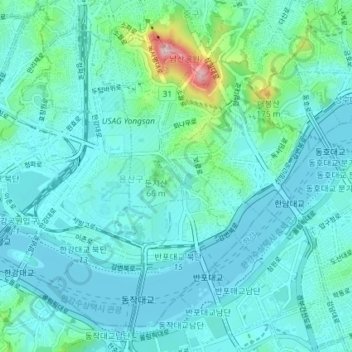
Nome: Mapa topográfico Yongsan-gu, altitude, relevo.
Local: Yongsan-gu, Seoul, South Korea (37.50647 126.94458 37.55564 127.01752)
Altitude média: 39 m
Altitude mínima: 2 m
Altitude máxima: 265 m
Yongsan is located next to the Han River, with level ground in the west of the district which has been used for transportation (rail) and commercial use since the early 20th century. To the east and north in the land is steeper and rises towards Namsan which lies to the north. Namsan has an elevation of 243m and consists mostly of granite. The low lying western section of the district is approximately 15-20 above sea level. This low-lying area has been prone to flooding during periods of heavy rainfall, a common issue with most of the low lying riverside districts in the city.
Outros mapas topográficos
Clique em um mapa para visualizar sua topografia, sua altitude e seu relevo.
Pyeongchang-dong
Pyeongchang-dong, Jongno-gu, Seoul, South Korea
Altitude média: 268 m
Bangbae-dong
South Korea > Seoul > Seocho-gu > Bangbae-dong
Bangbae-dong, Seocho-gu, Seoul, South Korea
Altitude média: 79 m
Samseong-dong
South Korea > Seoul > Gangnam-gu > Samseong-dong
Samseong-dong, Gangnam-gu, Seoul, South Korea
Altitude média: 35 m
Mangu-dong
South Korea > Seoul > Mangu-dong
Mangu-dong, Jungnang-gu, Seoul, Nowon-gu, South Korea
Altitude média: 75 m
Ssangmun-dong
South Korea > Seoul > Ssangmun-dong
Ssangmun-dong, Dobong-gu, Seoul, Nowon-gu, South Korea
Altitude média: 49 m
Seoul
South Korea > Seoul > Songpa-gu
Jamsil 7(chil)-dong, Songpa-gu, Seoul, 05571, South Korea
Altitude média: 22 m
Seoul
South Korea > Seoul > Eunpyeong-gu
Gusan-dong, Eunpyeong-gu, Seoul, South Korea
Altitude média: 52 m
Seoul
South Korea > Seoul > Eunpyeong-gu
Nokbeon-dong, Eunpyeong-gu, Seoul, South Korea
Altitude média: 77 m
Euljiro 7-ga
South Korea > Seoul > Jung-gu > Euljiro 7-ga
Euljiro 7-ga, Jung-gu, Seoul, 04566, South Korea
Altitude média: 55 m