
Faça uma doação
Prepare-se para a sua próxima aventura:
Como Associado da Amazon, este site recebe uma comissão sobre compras elegíveis sem custo adicional para si.
Mapa topográfico Lewiston
Clique no mapa para exibir a altitude.
Faça uma doação
Prepare-se para a sua próxima aventura:
Como Associado da Amazon, este site recebe uma comissão sobre compras elegíveis sem custo adicional para si.
Lewiston
According to the U.S. Census Bureau, the city has a total area of 18.04 square miles (46.72 km2), of which 17.23 square miles (44.63 km2) is land and 0.81 square miles (2.10 km2) is water. Downtown Lewiston, at elevations between 740 feet (230 m) and 780 feet (240 m), is only slightly higher in elevation than the river, about 741 ft (226 m), which was thirty feet (9 m) lower prior to the completion of the Lower Granite Dam. Away from downtown the terrain gains elevation quickly, as the steep riverbank highway of U.S. 95 north of Lewiston ascends to 2,756 feet (840 m).
Faça uma doação
Prepare-se para a sua próxima aventura:
Como Associado da Amazon, este site recebe uma comissão sobre compras elegíveis sem custo adicional para si.
Sobre este mapa
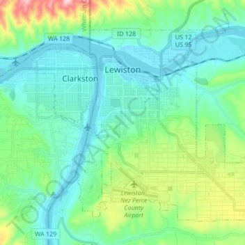
Nome: Mapa topográfico Lewiston, altitude, relevo.
Local: Lewiston, Nez Perce County, Idaho, United States (46.36165 -117.04659 46.43711 -116.91126)
Altitude média: 334 m
Altitude mínima: 219 m
Altitude máxima: 758 m
Faça uma doação
Prepare-se para a sua próxima aventura:
Como Associado da Amazon, este site recebe uma comissão sobre compras elegíveis sem custo adicional para si.