
Mapa topográfico Lachung
Mapa interativo
Clique no mapa para exibir a altitude.
Sobre este mapa
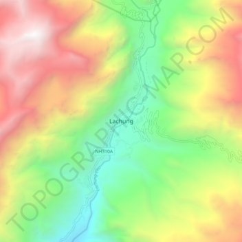
Nome: Mapa topográfico Lachung, altitude, relevo.
Local: Lachung, Chungthang, Mangan District, Sikkim, India (27.64971 88.70259 27.72971 88.78259)
Altitude média: 3617 m
Altitude mínima: 2281 m
Altitude máxima: 5366 m
Lachung is a town and hill station in northeast Sikkim, India. It is located in the North Sikkim district near the border with Tibet. Lachung is at an elevation of about 9,600 feet (2,900 m) and at the confluence of the lachen and Lachung Rivers, both tributaries of the River Teesta. The word Lachung means "small pass". The town is approximately 125 kilometres (78 mi) from the capital Gangtok.
Outros mapas topográficos
Clique em um mapa para visualizar sua topografia, sua altitude e seu relevo.
South Lhonak Glacier
India > Sikkim > Chungthang
South Lhonak Glacier, Chungthang, Mangan District, Sikkim, India
Altitude média: 5830 m
Lachung Chu
India > Sikkim > Chungthang > Lachung
Lachung Chu, Lachung, Chungthang, North Sikkim District, Sikkim, India
Altitude média: 4332 m
Gurudongmar
India > Sikkim > Chungthang
Gurudongmar, Chungthang, North Sikkim District, Sikkim, India
Altitude média: 5232 m