
Mapa topográfico Manorville
Mapa interativo
Clique no mapa para exibir a altitude.
Sobre este mapa
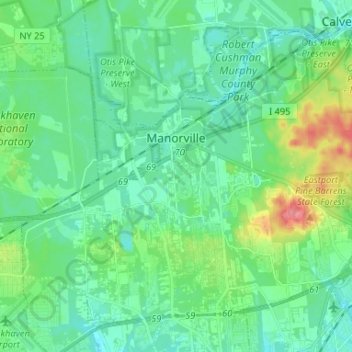
Nome: Mapa topográfico Manorville, altitude, relevo.
Altitude média: 22 m
Altitude mínima: 4 m
Altitude máxima: 80 m
Manorville is in the center of Long Island with no access to the water. It lies partially on the Ronkonkoma terminal moraine, which creates some slightly rolling topography, especially in the central portion of the hamlet. The glacial topography of the area features several kettle hole ponds, the most well-known of which is Punk's Hole, where a Revolutionary War captain was rumored to have hid from the British.
Outros mapas topográficos
Clique em um mapa para visualizar sua topografia, sua altitude e seu relevo.
Mastic
United States > New York > Suffolk County > Town of Brookhaven
Mastic, Town of Brookhaven, Suffolk County, New York, 11950, United States
Altitude média: 14 m
North Bellport
United States > New York > Suffolk County > Town of Brookhaven
North Bellport, Town of Brookhaven, Suffolk County, New York, 11713, United States
Altitude média: 17 m
Coram
United States > New York > Suffolk County > Town of Brookhaven
Coram, Town of Brookhaven, Suffolk County, New York, 11727, United States
Altitude média: 40 m
Farmingville
United States > New York > Suffolk County > Town of Brookhaven
Farmingville, Town of Brookhaven, Suffolk County, New York, 11738, United States
Altitude média: 48 m
Water Island
United States > New York > Suffolk County > Town of Brookhaven
Water Island, Fire Island, Town of Brookhaven, Suffolk County, New York, United States
Altitude média: 0 m
Port Jefferson Harbor
United States > New York > Suffolk County > Town of Brookhaven
Port Jefferson Harbor, Town of Brookhaven, Suffolk County, New York, United States
Altitude média: 10 m
Port Jefferson Station
United States > New York > Suffolk County > Town of Brookhaven
Port Jefferson Station, Town of Brookhaven, Suffolk County, New York, United States
Altitude média: 48 m
Stony Brook
United States > New York > Suffolk County > Town of Brookhaven
Stony Brook, Town of Brookhaven, Suffolk County, New York, United States
Altitude média: 29 m
Fire Island
United States > New York > Suffolk County > Town of Brookhaven
Fire Island, Town of Brookhaven, Suffolk County, New York, United States
Altitude média: 0 m
Stony Brook University
United States > New York > Suffolk County > Town of Brookhaven
Stony Brook University, Town of Brookhaven, Suffolk County, New York, 11794, United States
Altitude média: 46 m
East Patchogue
United States > New York > Suffolk County > Town of Brookhaven
East Patchogue, Town of Brookhaven, Suffolk County, New York, 11772, United States
Altitude média: 10 m
Mount Sinai
United States > New York > Suffolk County > Town of Brookhaven
Mount Sinai, Town of Brookhaven, Suffolk County, New York, 11766, United States
Altitude média: 37 m
Mastic Beach
United States > New York > Suffolk County > Town of Brookhaven
Mastic Beach, Town of Brookhaven, Suffolk County, New York, 11951, United States
Altitude média: 3 m
Rocky Point
United States > New York > Suffolk County > Town of Brookhaven
Rocky Point, Town of Brookhaven, Suffolk County, New York, 11778, United States
Altitude média: 31 m
Middle Island
United States > New York > Suffolk County > Town of Brookhaven
Middle Island, Town of Brookhaven, Suffolk County, New York, 11953, United States
Altitude média: 31 m
Village of Old Field
United States > New York > Suffolk County > Town of Brookhaven
Village of Old Field, Town of Brookhaven, Suffolk County, New York, United States
Altitude média: 5 m
Miller Place
United States > New York > Suffolk County > Town of Brookhaven
Miller Place, Town of Brookhaven, Suffolk County, New York, 11764, United States
Altitude média: 34 m
Village of Belle Terre
United States > New York > Suffolk County > Town of Brookhaven
Village of Belle Terre, Town of Brookhaven, Suffolk County, New York, United States
Altitude média: 20 m
Shirley
United States > New York > Suffolk County > Town of Brookhaven
Shirley, Town of Brookhaven, Suffolk County, New York, 11967, United States
Altitude média: 11 m
Centereach
United States > New York > Suffolk County > Town of Brookhaven
Centereach, Town of Brookhaven, Suffolk County, New York, 11720, United States
Altitude média: 39 m
Lake Ronkonkoma
United States > New York > Suffolk County > Town of Brookhaven
Lake Ronkonkoma, Town of Brookhaven, Suffolk County, New York, 11779, United States
Altitude média: 37 m
Selden
United States > New York > Suffolk County > Town of Brookhaven
Selden, Town of Brookhaven, Suffolk County, New York, 11784, United States
Altitude média: 41 m
Ridge
United States > New York > Suffolk County > Town of Brookhaven
Ridge, Town of Brookhaven, Suffolk County, New York, 11961, United States
Altitude média: 28 m
Holtsville
United States > New York > Suffolk County > Town of Brookhaven
Holtsville, Town of Brookhaven, Suffolk County, New York, 11742, United States
Altitude média: 30 m
North Patchogue
United States > New York > Suffolk County > Town of Brookhaven
North Patchogue, Town of Brookhaven, Suffolk County, New York, United States
Altitude média: 15 m
Terryville
United States > New York > Suffolk County > Town of Brookhaven
Terryville, Town of Brookhaven, Suffolk County, New York, 11776, United States
Altitude média: 48 m
Fire Island
United States > New York > Suffolk County > Town of Brookhaven
Fire Island, Town of Brookhaven, Suffolk County, New York, United States
Altitude média: 13 m
Yaphank
United States > New York > Suffolk County > Town of Brookhaven
Yaphank, Town of Brookhaven, Suffolk County, New York, 11980, United States
Altitude média: 24 m
Village of Shoreham
United States > New York > Suffolk County > Town of Brookhaven
Village of Shoreham, Town of Brookhaven, Suffolk County, New York, United States
Altitude média: 33 m
Blue Point
United States > New York > Suffolk County > Town of Brookhaven
Blue Point, Town of Brookhaven, Suffolk County, New York, 11715, United States
Altitude média: 7 m