
Mapa topográfico Menzingen
Mapa interativo
Clique no mapa para exibir a altitude.
Sobre este mapa
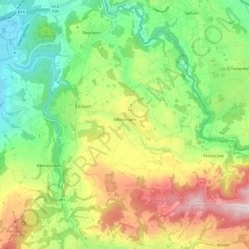
Nome: Mapa topográfico Menzingen, altitude, relevo.
Local: Menzingen, Zug, 6313, Switzerland (47.14806 8.55440 47.20524 8.66577)
Altitude média: 740 m
Altitude mínima: 443 m
Altitude máxima: 1195 m
The municipality is located on a moraine plateau between the Lorze and Sihl rivers at an elevation of about 800 m (2,600 ft). In 1848 the municipality of Neuheim separated from Menzingen. It consists of the village of Menzingen and a number of hamlets and individual farm houses.
Outros mapas topográficos
Clique em um mapa para visualizar sua topografia, sua altitude e seu relevo.