
Mapa topográfico Timnath
Clique no mapa para exibir a altitude.
Sobre este mapa
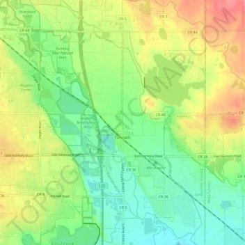
Nome: Mapa topográfico Timnath, altitude, relevo.
Local: Timnath, Larimer County, Colorado, 80547, United States (40.49174 -104.99185 40.57746 -104.94409)
Altitude média: 1493 m
Altitude mínima: 1462 m
Altitude máxima: 1536 m
Outros mapas topográficos
Clique em um mapa para visualizar sua topografia, sua altitude e seu relevo.
Estes Park
United States > Colorado > Larimer County
Estes Park sits at an elevation of 7,522 feet (2,293 m) on the front range of the Rocky Mountains at the eastern entrance of the Rocky Mountain National Park. Its location is 40°22′22″N 105°31′09″W / 40.372856°N 105.519136°W / 40.372856; -105.519136. Its north, south and east extremities…
Altitude média: 2543 m
Estes Park
United States > Colorado > Larimer County
Estes Park sits at an elevation of 7,522 feet (2,293 m) on the front range of the Rocky Mountains at the eastern entrance of the Rocky Mountain National Park. Its north, south and east extremities border the Roosevelt National Forest. Lumpy Ridge lies immediately north of Estes Park.
Altitude média: 2420 m
Stanley Heights Subdivision
United States > Colorado > Larimer County > Estes Park
Altitude média: 2345 m
Silver Lake
United States > Colorado > Larimer County > Loveland > Browns Corner
Altitude média: 1524 m
Estes Park
United States > Colorado > Larimer County
Estes Park sits at an elevation of 7,522 feet (2,293 m) on the front range of the Rocky Mountains at the eastern entrance of the Rocky Mountain National Park. Its north, south and east extremities border the Roosevelt National Forest. Lumpy Ridge lies immediately north of Estes Park.
Altitude média: 2543 m
Estes Park
United States > Colorado > Larimer County
Estes Park sits at an elevation of 7,522 feet (2,293 m) on the front range of the Rocky Mountains at the eastern entrance of the Rocky Mountain National Park. Its location is 40°22′22″N 105°31′09″W / 40.372856°N 105.519136°W / 40.372856; -105.519136. Its north, south and east extremities…
Altitude média: 2409 m
La Poudre Pass
United States > Colorado > Larimer County
La Poudre Pass (elevation 10,184 ft (3,104 m)), a high mountain pass, is located in the Rocky Mountains of northern Colorado in the United States.
Altitude média: 3218 m
La Poudre Pass
United States > Colorado > Larimer County
La Poudre Pass (elevation 10,184 ft (3,104 m)), a high mountain pass, is located in the Rocky Mountains of northern Colorado in the United States.
Altitude média: 3218 m
Horseshoe Lake (South Dam)
United States > Colorado > Larimer County > Loveland
Altitude média: 1515 m
Estes Park
United States > Colorado > Larimer County
Estes Park sits at an elevation of 7,658 feet (2,334 m) on the Front Range of the Rocky Mountains at the eastern entrance of the Rocky Mountain National Park. Its north, south and east extremities border the Roosevelt National Forest. Lumpy Ridge lies immediately north of Estes Park.
Altitude média: 2543 m
Estes Park
United States > Colorado > Larimer County
Estes Park sits at an elevation of 7,522 feet (2,293 m) on the front range of the Rocky Mountains at the eastern entrance of the Rocky Mountain National Park. Its north, south and east extremities border the Roosevelt National Forest. Lumpy Ridge lies immediately north of Estes Park.
Altitude média: 2429 m
Stanley Heights Subdivision
United States > Colorado > Larimer County > Estes Park
Altitude média: 2345 m