Geolocalizar

Mapa topográfico Calton Hill

Clique no mapa para exibir a altitude.

Sobre este mapa

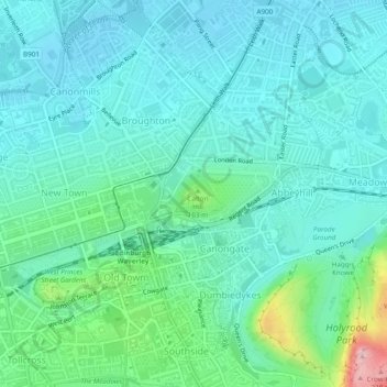
Nome: Mapa topográfico Calton Hill, altitude, relevo.

Local: Calton Hill, Greenside, New Town/Broughton, City of Edinburgh, Scotland, EH7 5AA, United Kingdom (55.95393 -3.18512 55.95682 -3.17893)

Altitude média: 54 m

Altitude mínima: 10 m

Altitude máxima: 240 m

Outros mapas topográficos

Clique em um mapa para visualizar sua topografia, sua altitude e seu relevo.

Ratho

United Kingdom > Scotland > City of Edinburgh

Altitude média: 80 m

Currie

United Kingdom > Scotland > City of Edinburgh

The period 1921-1951 brought great changes with the building of more council houses in Currie and private building along Lanark Road. Wider scale development began in the late 1950s and early 1960s with the construction of a private housing estate to the east of Curriehill Road. House builders began to promote…

Altitude média: 163 m

Hillend

United Kingdom > Scotland > City of Edinburgh > Ratho

Altitude média: 67 m

Balerno

United Kingdom > Scotland > City of Edinburgh

Altitude média: 287 m

Gogar

United Kingdom > Scotland > City of Edinburgh

Altitude média: 51 m

Hillend

United Kingdom > Scotland > City of Edinburgh > Ratho

Altitude média: 67 m

Prepare-se para a sua próxima aventura:

🌍Globos Terrestres - Compreender a geografia
👟Polainas Impermeáveis - Evitam a entrada de pedras, lama e neve no interior das botas
🧤Luvas Térmicas Táteis - Luvas quentes que permitem utilizar ecrãs de GPS e smartphones
🌲Equipamento Bushcraft - Vida ao ar livre
🧰Kits de Primeiros Socorros - Segurança em trilhos e viagens

Como Associado da Amazon, este site recebe uma comissão sobre compras elegíveis sem custo adicional para si.