
Mapa topográfico Ruthin
Mapa interativo
Clique no mapa para exibir a altitude.
Sobre este mapa
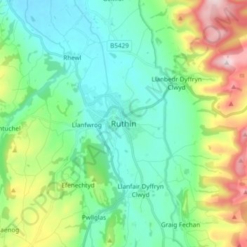
Nome: Mapa topográfico Ruthin, altitude, relevo.
Local: Ruthin, Denbighshire, Wales, LL15 1BU, United Kingdom (53.07155 -3.34524 53.15155 -3.26524)
Altitude média: 162 m
Altitude mínima: 35 m
Altitude máxima: 505 m
The Myddleton Arms is also known as the Seven Eyes. It is said to have been built in the 14th century. The Dutch style design, long, steeped roof is attributed to Sir Richard Clough, an Elizabethan merchant. It has four tiers of dormer windows, each at a different elevation, known locally as the seven eyes of Ruthin. The property was acquired in 1595 by Sir Hugh Myddleton, who provided London with it first fresh water supply. The view of The Myddleton on the square is in fact of the rear of the building. The front looks out over the Clwydian Hills.
Outros mapas topográficos
Clique em um mapa para visualizar sua topografia, sua altitude e seu relevo.
Tremeirchion
United Kingdom > Wales > Denbighshire
Tremeirchion, Denbighshire, Wales, United Kingdom
Altitude média: 123 m
Llangollen
United Kingdom > Wales > Denbighshire
Llangollen, Denbighshire, Wales, LL20 8PS, United Kingdom
Altitude média: 279 m
Denbigh
United Kingdom > Wales > Denbighshire
Denbigh, Denbighshire, Wales, LL16 3UN, United Kingdom
Altitude média: 102 m