
Faça uma doação
Prepare-se para a sua próxima aventura:
Como Associado da Amazon, este site recebe uma comissão sobre compras elegíveis sem custo adicional para si.
Mapa topográfico Ramos Arizpe
Clique no mapa para exibir a altitude.
Faça uma doação
Prepare-se para a sua próxima aventura:
Como Associado da Amazon, este site recebe uma comissão sobre compras elegíveis sem custo adicional para si.
Ramos Arizpe
Ramos Arizpe has a desert climate (Köppen climate classification BWh Owing to its altitude of 1,400 to 1,500 m (4,600 to 4,900 ft) above sea level, temperatures are milder than other desert cities at lower elevations. Winters are mild with warm temperatures during the day and cold nights. The January average temperature is 11.9 °C (53.4 °F). On average, temperatures drop below freezing on 18 days per year, which can occur in the months November to April. Occasionally, it can receive snowfall. Precipitation is low during the winter months and many days are clear and sunny, averaging 20-22 clear days from December to March.
Faça uma doação
Prepare-se para a sua próxima aventura:
Como Associado da Amazon, este site recebe uma comissão sobre compras elegíveis sem custo adicional para si.
Sobre este mapa
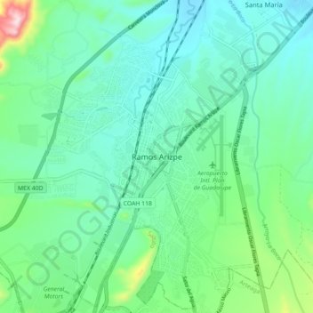
Nome: Mapa topográfico Ramos Arizpe, altitude, relevo.
Local: Ramos Arizpe, Coahuila, 25900, Mexico (25.50079 -100.98667 25.58079 -100.90667)
Altitude média: 1426 m
Altitude mínima: 1337 m
Altitude máxima: 1756 m
Faça uma doação
Prepare-se para a sua próxima aventura:
Como Associado da Amazon, este site recebe uma comissão sobre compras elegíveis sem custo adicional para si.