
Mapa topográfico Faßmannsreuth
Mapa interativo
Clique no mapa para exibir a altitude.
Sobre este mapa
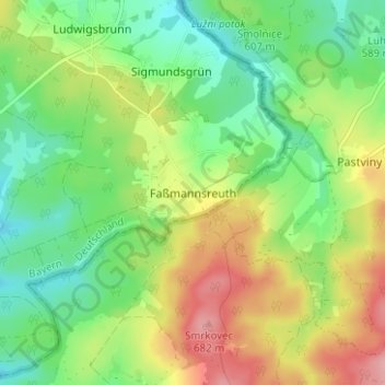
Nome: Mapa topográfico Faßmannsreuth, altitude, relevo.
Local: Faßmannsreuth, Rehau, Landkreis Hof, Bayern, Deutschland (50.25177 12.10446 50.29177 12.14446)
Altitude média: 615 m
Altitude mínima: 565 m
Altitude máxima: 691 m
Outros mapas topográficos
Clique em um mapa para visualizar sua topografia, sua altitude e seu relevo.
Heinersberg
Deutschland > Bayern > Landkreis Hof > Rehau
Heinersberg, Rehau, Landkreis Hof, Bayern, 95111, Deutschland
Altitude média: 567 m
Schönlind
Deutschland > Bayern > Landkreis Hof > Rehau
Schönlind, Rehau, Landkreis Hof, Bayern, 95173, Deutschland
Altitude média: 617 m