
Mapa topográfico High Roding
Clique no mapa para exibir a altitude.
Sobre este mapa
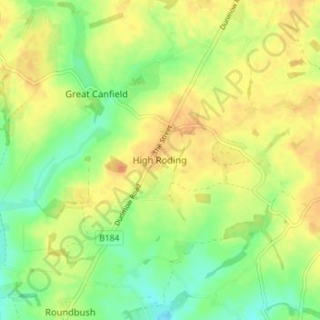
Nome: Mapa topográfico High Roding, altitude, relevo.
Local: High Roding, Uttlesford, Essex, England, CM6 1YH, United Kingdom (51.81016 0.30609 51.85016 0.34609)
Altitude média: 79 m
Altitude mínima: 61 m
Altitude máxima: 93 m
Outros mapas topográficos
Clique em um mapa para visualizar sua topografia, sua altitude e seu relevo.
Coles Green
United Kingdom > England > Essex > Uttlesford > Berden > Little London
Altitude média: 100 m
Stansted Mountfitchet
United Kingdom > England > Essex > Uttlesford > Stansted Mountfitchet
Altitude média: 89 m
Little Easton
United Kingdom > England > Essex > Uttlesford > Little Easton
Living in the parish were Lord and Lady Brooke, the later Earl and Countess of Warwick, at Easton Lodge, who were also resident at Berwick House in the Stable Yard of St James's Palace, London, and in 1902, after elevation to title, Warwick Castle. Parish occupations in 1882 included three farmers, one of whom…
Altitude média: 88 m
Great Hallingbury
United Kingdom > England > Essex > Uttlesford > Great Hallingbury
Altitude média: 81 m