
Mapa topográfico Corbion
Mapa interativo
Clique no mapa para exibir a altitude.
Sobre este mapa
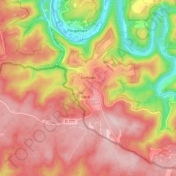
Nome: Mapa topográfico Corbion, altitude, relevo.
Altitude média: 344 m
Altitude mínima: 190 m
Altitude máxima: 443 m
Outros mapas topográficos
Clique em um mapa para visualizar sua topografia, sua altitude e seu relevo.
Noirefontaine
België > Luxemburg > Neufchâteau > Bouillon > Noirefontaine
Noirefontaine, Bouillon, Neufchâteau, Luxemburg, Wallonië, 6831, België
Altitude média: 331 m
Dohan
België > Luxemburg > Neufchâteau > Bouillon
Dohan, Bouillon, Neufchâteau, Luxemburg, Wallonië, België
Altitude média: 284 m
Rochehaut
België > Luxemburg > Neufchâteau > Bouillon
Rochehaut, Bouillon, Neufchâteau, Luxemburg, Wallonië, België
Altitude média: 298 m
Poupehan
België > Luxemburg > Neufchâteau > Bouillon
Poupehan, Bouillon, Neufchâteau, Luxemburg, Wallonië, België
Altitude média: 270 m