
Faça uma doação
Prepare-se para a sua próxima aventura:
Como Associado da Amazon, este site recebe uma comissão sobre compras elegíveis sem custo adicional para si.
Mapa topográfico San Cristóbal
Clique no mapa para exibir a altitude.
Faça uma doação
Prepare-se para a sua próxima aventura:
Como Associado da Amazon, este site recebe uma comissão sobre compras elegíveis sem custo adicional para si.
San Cristóbal
The city and municipality are located in a region called the Chiapas Highlands or Central Highlands. Two thirds of the municipality is made up of mountainous terrain with the rest valley floor. The city proper is located at 2,200 meters above sea level in a small valley surrounded by hills. The most important of these hills include Cerro Huitepec, San José Bocomtenelté, Cerro San Felipe, Cerro El Extranjero, Cerro Cruz Carreta, El Arcotete and Cerro Tzontehuitz. While it is in a tropical zone, its climate is temperate due to the altitude. The climate is also humid, with cloud cover in the winter months that keeps temperatures down and can produce cold nights. Average temperature between December and April is 18 °C. The area receives most of its rain in the summer to early fall. However, the cloud cover that exists in winter is generally absent and daytime temperatures can go up to 35 °C with high humidity.
Faça uma doação
Prepare-se para a sua próxima aventura:
Como Associado da Amazon, este site recebe uma comissão sobre compras elegíveis sem custo adicional para si.
Sobre este mapa
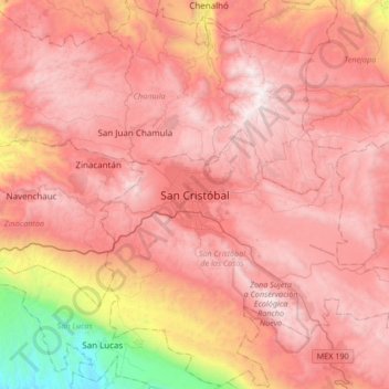
Nome: Mapa topográfico San Cristóbal, altitude, relevo.
Altitude média: 2038 m
Altitude mínima: 456 m
Altitude máxima: 2881 m
Faça uma doação
Prepare-se para a sua próxima aventura:
Como Associado da Amazon, este site recebe uma comissão sobre compras elegíveis sem custo adicional para si.