
Mapa topográfico Town of Middlebury
Mapa interativo
Clique no mapa para exibir a altitude.
Sobre este mapa
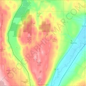
Nome: Mapa topográfico Town of Middlebury, altitude, relevo.
Local: Town of Middlebury, Wyoming County, New York, United States (42.78233 -78.19139 42.87038 -78.07407)
Altitude média: 401 m
Altitude mínima: 285 m
Altitude máxima: 523 m
Outros mapas topográficos
Clique em um mapa para visualizar sua topografia, sua altitude e seu relevo.
Village of Castile
United States > New York > Wyoming County
Village of Castile, Town of Castile, Wyoming County, New York, United States
Altitude média: 420 m
Java Center
United States > New York > Wyoming County
Java Center, Town of Java, Wyoming County, New York, 14082, United States
Altitude média: 471 m
Rock Glen
United States > New York > Wyoming County
Rock Glen, Town of Gainesville, Wyoming County, New York, 14550, United States
Altitude média: 426 m
Town of Covington
United States > New York > Wyoming County
Town of Covington, Wyoming County, New York, United States
Altitude média: 348 m