
Mapa topográfico Mbala
Mapa interativo
Clique no mapa para exibir a altitude.
Sobre este mapa
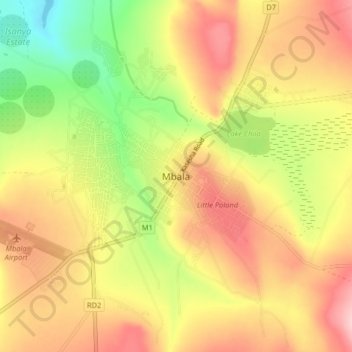
Nome: Mapa topográfico Mbala, altitude, relevo.
Local: Mbala, Mbala District, Northern Province, Zambia (-8.88561 31.33092 -8.80561 31.41092)
Altitude média: 1632 m
Altitude mínima: 1531 m
Altitude máxima: 1718 m
The town is at the edge of the plateau covering most of Zambia, at an elevation of 1670 m, about 900 m higher than Lake Tanganyika, which comes within 22 km (straight-line distance). The escarpment above the lake is the end of the Albertine Rift, the western branch of the East Africa Rift, and the Mbala area experiences occasional earth tremors. It is also said that the tiny but picturesque Lake Chila within the town experiences inexplicable drying out, and sudden flooding from underground springs, but this may be just a legend.
Outros mapas topográficos
Clique em um mapa para visualizar sua topografia, sua altitude e seu relevo.
Makoko
Makoko, Kaputa District, Northern Province, Zambia
Altitude média: 1044 m
Kasama
Kasama, Kasama District, Northern Province, Zambia
Altitude média: 1327 m
Kumbula Island
Zambia > Northern Province > Mpulungu
Kumbula Island, Mpulungu, Mpulungu District, Northern Province, Zambia
Altitude média: 776 m