
Mapa topográfico Oak Park
Mapa interativo
Clique no mapa para exibir a altitude.
Sobre este mapa
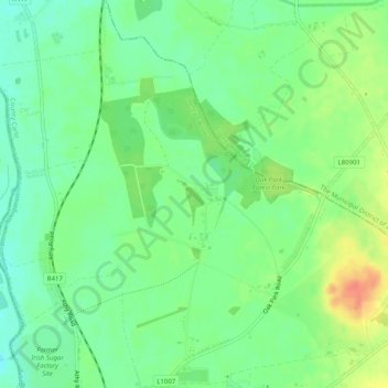
Nome: Mapa topográfico Oak Park, altitude, relevo.
Altitude média: 59 m
Altitude mínima: 40 m
Altitude máxima: 88 m
Outros mapas topográficos
Clique em um mapa para visualizar sua topografia, sua altitude e seu relevo.
St Mullins
St Mullins, The Municipal District of Muinebeag, The Municipal District of New Ross, County Carlow, Leinster, Ireland
Altitude média: 138 m
Greenoge
Greenoge, The Municipal District of Tullow, County Carlow, Leinster, Ireland
Altitude média: 272 m
Slievebawn
Slievebawn, The Municipal District of Muinebeag, County Carlow, Leinster, Ireland
Altitude média: 315 m
Myshall
Myshall, Myshall ED, The Municipal District of Tullow, County Carlow, Leinster, Ireland
Altitude média: 145 m
Leighlinbridge
Leighlinbridge, Leighlinbridge ED, The Municipal District of Muinebeag, County Carlow, Leinster, Ireland
Altitude média: 52 m
Agharue
Agharue, Rathornan ED, The Municipal District of Muinebeag, County Carlow, Leinster, Ireland
Altitude média: 236 m
The Municipal District of Tullow
The Municipal District of Tullow, County Carlow, Leinster, Ireland
Altitude média: 112 m
The Municipal District of Muinebeag
The Municipal District of Muinebeag, County Carlow, Leinster, Ireland
Altitude média: 129 m
Kinneagh Parish
Kinneagh Parish, The Municipal District of Tullow, County Carlow, Leinster, Ireland
Altitude média: 116 m
Ballinabranagh
Ballinabranagh, Clogrenan ED, The Municipal District of Muinebeag, County Carlow, Leinster, Ireland
Altitude média: 124 m
Ballintemple
Ballintemple, Ballintemple ED, The Municipal District of Tullow, County Carlow, Leinster, Ireland
Altitude média: 93 m
Killenora
Killenora, Johnstown ED, The Municipal District of Carlow, County Carlow, Leinster, Ireland
Altitude média: 73 m
Rathornan
Rathornan, Rathornan ED, The Municipal District of Muinebeag, County Carlow, Leinster, Ireland
Altitude média: 52 m
Lumcloon
Lumcloon, Fennagh ED, The Municipal District of Muinebeag, County Carlow, Leinster, Ireland
Altitude média: 96 m
Coolnamara Cross Roads
Coolnamara Cross Roads, Coolnamara, Marley ED, The Municipal District of Muinebeag, County Carlow, Leinster, R95 C792, Ireland
Altitude média: 65 m
Kellistown
Kellistown, The Municipal District of Tullow, County Carlow, Leinster, Ireland
Altitude média: 91 m
The Municipal District of Carlow
The Municipal District of Carlow, County Carlow, Leinster, Ireland
Altitude média: 71 m