
Mapa topográfico Indravati National Park
Mapa interativo
Clique no mapa para exibir a altitude.
Sobre este mapa
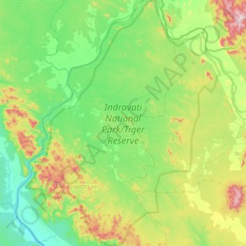
Nome: Mapa topográfico Indravati National Park, altitude, relevo.
Altitude média: 253 m
Altitude mínima: 90 m
Altitude máxima: 732 m
The topography of the park mainly comprises undulating hilly terrain with altitude ranging between 177 and 599 metres above the sea level.
Outros mapas topográficos
Clique em um mapa para visualizar sua topografia, sua altitude e seu relevo.
Bhairamgarh Tahsil
India > Chhattisgarh > Bijapur District
Bhairamgarh Tahsil, Bijapur District, Chhattisgarh, India
Altitude média: 386 m