
Faça uma doação
Prepare-se para a sua próxima aventura:
Como Associado da Amazon, este site recebe uma comissão sobre compras elegíveis sem custo adicional para si.
Mapa topográfico Ridgefield
Clique no mapa para exibir a altitude.
Faça uma doação
Prepare-se para a sua próxima aventura:
Como Associado da Amazon, este site recebe uma comissão sobre compras elegíveis sem custo adicional para si.
Ridgefield
Ridgefield consists of hilly, rocky terrain, ranging from 1,060 feet (320 m) above sea level (at Pine Mountain) to 342 feet (104 m) at Branchville. Its average village elevation is 725 feet (221 m) above sea level. The landscape is strewn with countless rocks deposited by glaciers, and among the town's bodies of water is Round Pond, formed in a kettle left by the last glacier 20,000 years ago. Another interesting body of water in the town is Mamanasco Lake, an 86-acre (35 ha) lake near Ridgefield High School. A particularly interesting feature is Cameron's Line, named for Eugene N. Cameron, who discovered that rocks west of the line differed greatly from those east of it. This fault line was formed some 250 million years ago by the collision of "Proto North America" and "Proto Africa", and there are still occasional light earthquakes felt along its length. The line bisects the southern half of the town, running generally north of West Lane, across the north end of the village, past the south end of Great Swamp and generally easterly into Redding in the Topstone area. North of Cameron's Line, the town is rich in limestone. The mineral was extensively mined, and remnants of several limekilns exist today. Also mined here in the 19th century was mica, pegmatite, and quartz. Gold, as well as gemstones such as garnet and beryl, have been found here, and dozens of minerals have been unearthed at the old Branchville Mica Quarry. Uraninite, a source of uranium, is found here, too.
Faça uma doação
Prepare-se para a sua próxima aventura:
Como Associado da Amazon, este site recebe uma comissão sobre compras elegíveis sem custo adicional para si.
Sobre este mapa
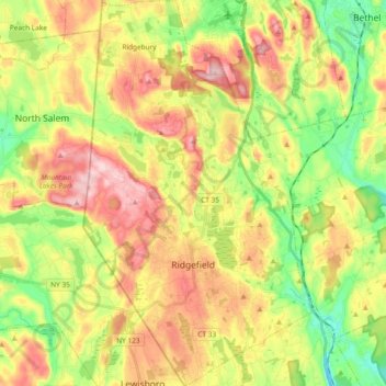
Nome: Mapa topográfico Ridgefield, altitude, relevo.
Altitude média: 183 m
Altitude mínima: 79 m
Altitude máxima: 301 m
Faça uma doação
Prepare-se para a sua próxima aventura:
Como Associado da Amazon, este site recebe uma comissão sobre compras elegíveis sem custo adicional para si.
Outros mapas topográficos
Clique em um mapa para visualizar sua topografia, sua altitude e seu relevo.
Cannondale
United States > Connecticut > Western Connecticut Planning Region > Wilton
Altitude média: 110 m