
Mapa topográfico Moros
Mapa interativo
Clique no mapa para exibir a altitude.
Sobre este mapa
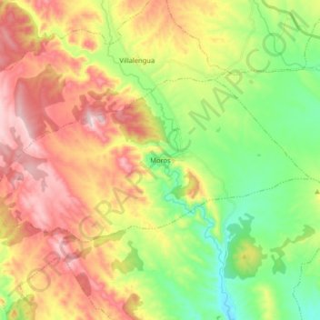
Nome: Mapa topográfico Moros, altitude, relevo.
Local: Moros, Comunidad de Calatayud, Zaragoza, Aragon, Spain (41.36687 -1.91315 41.42871 -1.75219)
Altitude média: 777 m
Altitude mínima: 586 m
Altitude máxima: 1013 m
Moros is one of the most attractive and picturesque villages of its kind in the area. Its narrow streets zigzag from the square at its highest elevation down to the river bed below. The houses are the main feature of the town. Hundreds of houses have been built tightly against the sunny side of the mountain. They are built with mud and decorated with red and ochre Arabic tiles. Each level of houses rises above the one beneath it to catch the sun as it rises over the valley.
Outros mapas topográficos
Clique em um mapa para visualizar sua topografia, sua altitude e seu relevo.
Calatayud
Spain > Aragon > Comunidad de Calatayud
Calatayud, Comunidad de Calatayud, Zaragoza, Aragon, 50300, Spain
Altitude média: 693 m
Ariza
Spain > Aragon > Comunidad de Calatayud
Ariza, Comunidad de Calatayud, Zaragoza, Aragon, 50220, Spain
Altitude média: 801 m
Mara
Spain > Aragon > Comunidad de Calatayud
Mara, Comunidad de Calatayud, Zaragoza, Aragon, Spain
Altitude média: 773 m
Alhama de Aragón
Spain > Aragon > Comunidad de Calatayud > Alhama de Aragón
Alhama de Aragón, Comunidad de Calatayud, Zaragoza, Aragon, Spain
Altitude média: 763 m