
Faça uma doação
Prepare-se para a sua próxima aventura:
Como Associado da Amazon, este site recebe uma comissão sobre compras elegíveis sem custo adicional para si.
Mapa topográfico Mount Rundle
Clique no mapa para exibir a altitude.
Faça uma doação
Prepare-se para a sua próxima aventura:
Como Associado da Amazon, este site recebe uma comissão sobre compras elegíveis sem custo adicional para si.
Mount Rundle
In Banff, the Spray River trailhead for the first peak taking the Mount Rundle Trail, is near the Spray River bridge on the road to the Banff Springs Golf Course. The all-day hike (from 8–10 hours) from the trailhead to the peak is about 5 kilometres (3.1 mi) one-way and has an elevation gain of about 993 metres (3,258 ft) to the cliff bank on the first peak and 1,579 metres (5,180 ft) to the summit. Although it is called non-technical, it is considered gruelling by some. About halfway up there is a Central Gully, a huge watercourse with a well-worn path which is a dead end. Cliffs become higher and more vertical and there is no scrambling route. The real route crosses the watercourse and then immediately turns left (watch for markings). As one passes the treeline, the hiker ventures onto a feature called the "Dragon's back", where the route narrows between two steep gullies. The only real obstacle at this point is perseverance at the tread-mill like scree which slows progress to a two steps forward, one step back pattern.
Faça uma doação
Prepare-se para a sua próxima aventura:
Como Associado da Amazon, este site recebe uma comissão sobre compras elegíveis sem custo adicional para si.
Sobre este mapa
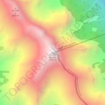
Nome: Mapa topográfico Mount Rundle, altitude, relevo.
Local: Mount Rundle, Improvement District No. 9, Alberta, Canada (51.12453 -115.46924 51.12463 -115.46914)
Altitude média: 2353 m
Altitude mínima: 1476 m
Altitude máxima: 2996 m
Faça uma doação
Prepare-se para a sua próxima aventura:
Como Associado da Amazon, este site recebe uma comissão sobre compras elegíveis sem custo adicional para si.
Outros mapas topográficos
Clique em um mapa para visualizar sua topografia, sua altitude e seu relevo.
Kootenay National Park
Canada > Alberta > Improvement District No. 9
Kootenay National Park is a national park of Canada located in southeastern British Columbia. The park consists of 1,406 km2 (543 sq mi) of the Canadian Rockies, including parts of the Kootenay and Park mountain ranges, the Kootenay River and the entirety of the Vermilion River. While the Vermilion River is…
Altitude média: 1833 m