
Mapa topográfico Mangalagiri
Mapa interativo
Clique no mapa para exibir a altitude.
Sobre este mapa
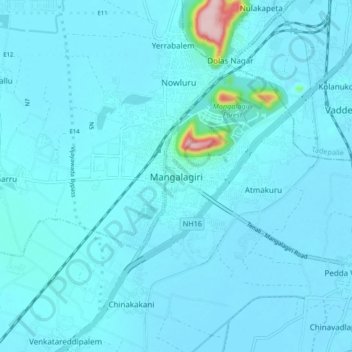
Nome: Mapa topográfico Mangalagiri, altitude, relevo.
Local: Mangalagiri, Guntur, Andhra Pradesh, 522500, India (16.39182 80.52881 16.47182 80.60881)
Altitude média: 29 m
Altitude mínima: 15 m
Altitude máxima: 245 m
Mangalagiri is located at 16°26′N 80°33′E / 16.43°N 80.55°E / 16.43; 80.55. It has an average elevation of 29.08 m (95.4 ft).It is located 26 kilometres (16 mi) north east of the district headquarters, Guntur, and just 10 km (6.2 mi) south west of Vijayawada and also 30 km (19 mi) to the north west of Tenali by road. It lies on hilly terrain. It falls under Seismic Zone 3.