Mapa topográfico Oshtoran Kuh
Mapa interativo
Clique no mapa para exibir a altitude.
Sobre este mapa
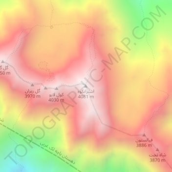
Nome: Mapa topográfico Oshtoran Kuh, altitude, relevo.
Altitude média: 3605 m
Altitude mínima: 2824 m
Altitude máxima: 4069 m

Clique no mapa para exibir a altitude.
Nome: Mapa topográfico Oshtoran Kuh, altitude, relevo.
Altitude média: 3605 m
Altitude mínima: 2824 m
Altitude máxima: 4069 m