
Mapa topográfico West Lafayette
Mapa interativo
Clique no mapa para exibir a altitude.
Sobre este mapa
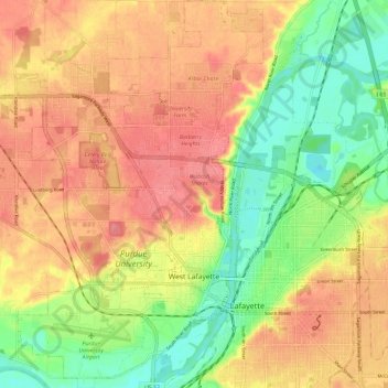
Nome: Mapa topográfico West Lafayette, altitude, relevo.
Local: West Lafayette, Tippecanoe County, Indiana, United States (40.40002 -86.96244 40.48954 -86.88698)
Altitude média: 192 m
Altitude mínima: 150 m
Altitude máxima: 225 m
West Lafayette lies in central Tippecanoe County and overlooks the Wabash River, which borders the city on the east and south. Most of the city lies in eastern Wabash Township, though a small portion on the northeast side extends into Tippecanoe Township. Elevations range from slightly over 500 feet (150 m) near the river to more than 720 feet (220 m) in northern parts of the city near U.S. Route 52.
Outros mapas topográficos
Clique em um mapa para visualizar sua topografia, sua altitude e seu relevo.
Happy Hollow Heights
United States > Indiana > Tippecanoe County > West Lafayette > Happy Hollow Heights
Happy Hollow Heights, West Lafayette, Tippecanoe County, Indiana, 46906, United States
Altitude média: 189 m
Buck Creek
United States > Indiana > Tippecanoe County
Buck Creek, Tippecanoe County, Indiana, 47924, United States
Altitude média: 202 m
Lafayette
United States > Indiana > Tippecanoe County > Lafayette
Lafayette, Tippecanoe County, Indiana, United States
Altitude média: 193 m