
Mapa topográfico Wels
Mapa interativo
Clique no mapa para exibir a altitude.
Wels
Wels is in the Hausruckviertel at an elevation of 317 m. From north to south, it extends over 9.5 km, from west to east over 9.6 km. 3.4% of the area is covered with forest, 23.5% is used for agriculture.
Sobre este mapa
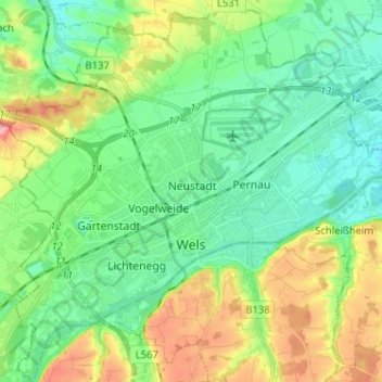
Nome: Mapa topográfico Wels, altitude, relevo.
Local: Wels, Upper Austria, 4600, Austria (48.12582 13.96353 48.21131 14.09076)
Altitude média: 337 m
Altitude mínima: 298 m
Altitude máxima: 423 m
Outros mapas topográficos
Clique em um mapa para visualizar sua topografia, sua altitude e seu relevo.
Hochficht / Smrčina
Austria > Upper Austria > Bezirk Rohrbach > Klaffer am Hochficht
Altitude média: 1150 m
Hochficht / Smrčina
Austria > Upper Austria > Bezirk Rohrbach > Klaffer am Hochficht
Altitude média: 1150 m
Bad Goisern
Austria > Upper Austria > Bezirk Gmunden > Bad Goisern am Hallstättersee > Bad Goisern
Altitude média: 644 m
Au an der Traun
Austria > Upper Austria > Bezirk Wels-Land > Marchtrenk > Au an der Traun
Altitude média: 305 m
Schlögen
Austria > Upper Austria > Bezirk Eferding > Haibach ob der Donau > Schlögen
Altitude média: 458 m