
Mapa topográfico Odesa
Mapa interativo
Clique no mapa para exibir a altitude.
Sobre este mapa
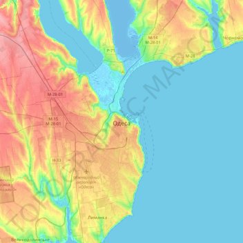
Nome: Mapa topográfico Odesa, altitude, relevo.
Altitude média: 26 m
Altitude mínima: -8 m
Altitude máxima: 83 m
Odesa is situated (46°28′N 30°44′E / 46.467°N 30.733°E / 46.467; 30.733) on terraced hills overlooking a small harbor on the Black Sea in the Gulf of Odesa, approximately 31 km (19 mi) north of the estuary of the Dniester river and some 443 km (275 mi) south of the Ukrainian capital Kyiv. The average elevation at which the city is located is around 50 metres (160 feet). The maximum is 65 metres (213 feet) and minimum (on the coast) amounts to 4.2 metres (13.8 feet) above sea level. The city currently covers a territory of 162.42 km2 (63 sq mi).
Outros mapas topográficos
Clique em um mapa para visualizar sua topografia, sua altitude e seu relevo.
Kyivs'kyi Rayon
Ukraine > Odesa Oblast > Odesa
Kyivs'kyi Rayon, Odesa, Одеська міська громада, Odesa Raion, Odesa Oblast, Ukraine
Altitude média: 29 m