
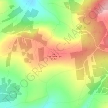
Mapa topográfico Knockawarriga
Mapa interativo
Clique no mapa para exibir a altitude.
Sobre este mapa
Nome: Mapa topográfico Knockawarriga, altitude, relevo.
Altitude média: 247 m
Altitude mínima: 166 m
Altitude máxima: 327 m
Outros mapas topográficos
Clique em um mapa para visualizar sua topografia, sua altitude e seu relevo.
Churchtown
Ireland > County Limerick > The Municipal District of Newcastle West
Churchtown, Newcastle Urban, The Municipal District of Newcastle West, County Limerick, Munster, V42 P682, Ireland
Altitude média: 66 m
Athea
Ireland > County Limerick > The Municipal District of Newcastle West
Athea, The Municipal District of Newcastle West, County Limerick, Munster, Ireland
Altitude média: 114 m
Newcastle
Ireland > County Limerick > The Municipal District of Newcastle West
Newcastle, The Municipal District of Newcastle West, County Limerick, Munster, V42 P682, Ireland
Altitude média: 92 m
Caheragh
Ireland > County Limerick > The Municipal District of Newcastle West
Caheragh, Glin, The Municipal District of Newcastle West, County Limerick, Munster, Ireland
Altitude média: 26 m
Crataloe East
Ireland > County Limerick > The Municipal District of Newcastle West
Crataloe East, Rathronan, The Municipal District of Newcastle West, County Limerick, Munster, Ireland
Altitude média: 184 m
Killard
Ireland > County Limerick > The Municipal District of Newcastle West
Killard, Ardagh ED, The Municipal District of Newcastle West, County Limerick, Munster, Ireland
Altitude média: 61 m
Crataloe West
Ireland > County Limerick > The Municipal District of Newcastle West
Crataloe West, Rathronan, The Municipal District of Newcastle West, County Limerick, Munster, Ireland
Altitude média: 153 m
Ballaghbehy
Ireland > County Limerick > The Municipal District of Newcastle West
Ballaghbehy, Dromtrasna, The Municipal District of Newcastle West, County Limerick, Munster, Ireland
Altitude média: 135 m
Coolacokery
Ireland > County Limerick > The Municipal District of Newcastle West
Coolacokery, Ardagh ED, The Municipal District of Newcastle West, County Limerick, Munster, Ireland
Altitude média: 52 m