
Mapa topográfico Glasgow
Mapa interativo
Clique no mapa para exibir a altitude.
Sobre este mapa
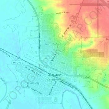
Nome: Mapa topográfico Glasgow, altitude, relevo.
Local: Glasgow, Valley County, Montana, 59230, United States (48.18836 -106.65042 48.21255 -106.61272)
Altitude média: 654 m
Altitude mínima: 633 m
Altitude máxima: 700 m
According to the United States Census Bureau, the city has a total area of 1.43 square miles (3.7 km2), all of it land. The town has an elevation of 2,093 feet (638 m) and is nestled in the Milk River Valley.