
Mapa topográfico Anshun
Mapa interativo
Clique no mapa para exibir a altitude.
Anshun
Anshun's administrative area spans latitude 25° 21'−26° 38' N and longitude 105° 13'−106° 34' E and contains sizeable areas of karst formation. It borders Guiyang, the provincial capital, and Qiannan Buyei and Miao Autonomous Prefecture to the east, Liupanshui to the west, Qianxinan Buyei and Miao Autonomous Prefecture to the south, and Bijie to the north. Within the prefecture, the elevation ranges from 1,102 to 1,694 metres (3,615 to 5,558 ft).
Sobre este mapa
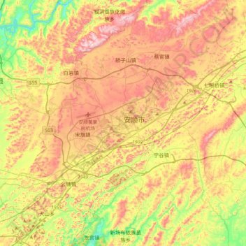
Nome: Mapa topográfico Anshun, altitude, relevo.
Local: Anshun, Xixiu District, Anshun City, Guizhou, 561000, China (26.08970 105.76778 26.40970 106.08778)
Altitude média: 1374 m
Altitude mínima: 1105 m
Altitude máxima: 1655 m