
Mapa topográfico Nestani
Mapa interativo
Clique no mapa para exibir a altitude.
Sobre este mapa
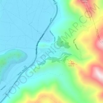
Nome: Mapa topográfico Nestani, altitude, relevo.
Altitude média: 827 m
Altitude mínima: 623 m
Altitude máxima: 1422 m
It is situated at the foot of the mountain Artemisio, at about 700 m elevation. It was the seat of the former municipality Mantineia. The community Nestani also contains the village of Milea. Nestani is 11 km east of Kapsas, 13 km southwest of Lyrkeia (Argolis) and 14 km northeast of Tripoli. The Moreas Motorway (Corinth–Tripoli-Kalamata/Sparta) passes west of the village.
Outros mapas topográficos
Clique em um mapa para visualizar sua topografia, sua altitude e seu relevo.
Tower of Nestani
Greece > Peloponnese, Western Greece and the Ionian > Arcadia Regional Unit > Municipal Unit of Mantineia
Tower of Nestani, Corinth - Tripoli - Kalamata, κ. Σάγκα, Community of Nestani, Municipal Unit of Mantineia, Municipality of Tripoli, Arcadia Regional Unit, Peloponnese Region, Peloponnese, Western Greece and the Ionian, 220 05, Greece
Altitude média: 753 m