

Mapa topográfico Jabalpur
Clique no mapa para exibir a altitude.
Jabalpur
The Narmada river bringing in freshwater from the Vindyachal Ranges has developed Jabalpur district into an agrarian economy. The land of the Narmada basin with its fertile alluvial soil gives good yields of sorghum, wheat, rice, and millet in the villages around Jabalpur. Important among commercial crops are pulses, oilseeds, cotton, sugar cane, and medicinal crops. The state is poised for a breakthrough in soybean cultivation. In Kharif crops occupy 60% and Rabi crops 40% area with 71.4% area under food grain production. Nearly 59% of landholders are marginal whereas small farmed share 18% of farmland. Low literacy rates (35.45%), undulating topography, high percentages of wasteland (13.2%), underdeveloped irrigation potential (23%), low groundwater utilization, a large proportion of rain-fed agriculture (75%), the practice of Kharif fallows (3.6%), low cropping intensity (131%), low fertilizer consumption (50 kg/ha), a high proportion of low-value crops, and high numbers of unproductive livestock constrain production in the state.
Sobre este mapa
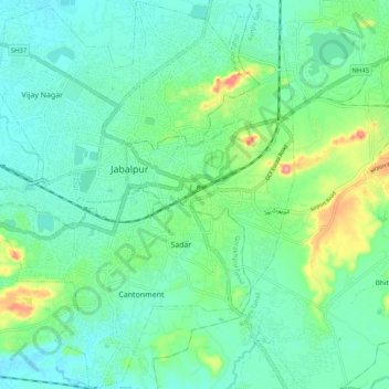
Nome: Mapa topográfico Jabalpur, altitude, relevo.
Local: Jabalpur, Ranjhi Tahsil, Jabalpur, Madhya Pradesh, India (23.11607 79.88308 23.21106 79.97620)
Altitude média: 408 m
Altitude mínima: 379 m
Altitude máxima: 497 m
Outros mapas topográficos
Clique em um mapa para visualizar sua topografia, sua altitude e seu relevo.

Jabalpur
India > Madhya Pradesh > Ranjhi Tahsil
The Narmada river bringing in freshwater from the Vindyachal Ranges has developed Jabalpur district into an agrarian economy. The land of the Narmada basin with its fertile alluvial soil gives good yields of sorghum, wheat, rice, and millet in the villages around Jabalpur. Important among commercial crops are…
Altitude média: 408 m
