
Mapa topográfico Tasmania
Mapa interativo
Clique no mapa para exibir a altitude.
Sobre este mapa
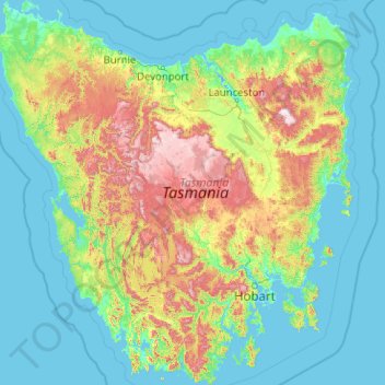
Nome: Mapa topográfico Tasmania, altitude, relevo.
Local: Tasmania, Australia (-43.64304 144.60734 -40.64139 148.35910)
Altitude média: 220 m
Altitude mínima: -3 m
Altitude máxima: 1524 m
The most mountainous region is the Central Highlands area, which covers most of the central western parts of the state. The Midlands located in the central east, is fairly flat, and is predominantly used for agriculture, although farming activity is scattered throughout the state. Tasmania's tallest mountain is Mount Ossa at 1,617 m (5,305 ft). Much of Tasmania is still densely forested, with the Southwest National Park and neighbouring areas holding some of the last temperate rain forests in the Southern Hemisphere. The Tarkine, containing Savage River National Park located in the island's far north west, is the largest temperate rainforest area in Australia covering about 3,800 square kilometres (1,500 sq mi). With its rugged topography, Tasmania has a great number of rivers. Several of Tasmania's largest rivers have been dammed at some point to provide hydroelectricity. Many rivers begin in the Central Highlands and flow out to the coast. Tasmania's major population centres are mainly situated around estuaries (some of which are named rivers).
Outros mapas topográficos
Clique em um mapa para visualizar sua topografia, sua altitude e seu relevo.
Freycinet Peninsula
Freycinet Peninsula, Glamorgan-Spring Bay, Tasmania, Australia
Altitude média: 303 m
Adventure Bay
Adventure Bay, Kingborough, Tasmania, 7150, Australia
Altitude média: 110 m
Broad River
Australia > Tasmania > Ellendale
Broad River, Ellendale, Central Highlands, Tasmania, 7140, Australia
Altitude média: 709 m
Seymour Conservation Area
Australia > Tasmania > Seymour
Seymour Conservation Area, Seymour, Break O'Day, Tasmania, Australia
Altitude média: 19 m
Cockle Creek
Australia > Tasmania > Recherche
Cockle Creek, Recherche, Huon Valley, Tasmania, Australia
Altitude média: 64 m
Launceston
Launceston, City of Launceston, Tasmania, 7250, Australia
Altitude média: 26 m
Anderson Island
Anderson Island, Flinders Council, Tasmania, Australia
Altitude média: 4 m
Lower Longley
Australia > Tasmania > Lower Longley
Lower Longley, Tasmania, Australia
Altitude média: 351 m
Breadalbane
Australia > Tasmania > Breadalbane
Breadalbane, Tasmania, 7212, Australia
Altitude média: 176 m
Randalls Bay
Australia > Tasmania > Randalls Bay
Randalls Bay, Tasmania, Australia
Altitude média: 49 m
Bathurst Harbour
Bathurst Harbour, Mount Beattie Track, Tasmania, Australia
Altitude média: 139 m