
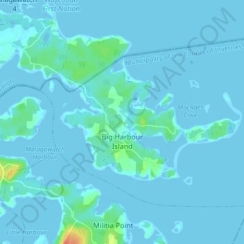
Mapa topográfico Big Harbour Island
Mapa interativo
Clique no mapa para exibir a altitude.
Sobre este mapa
Nome: Mapa topográfico Big Harbour Island, altitude, relevo.
Altitude média: 3 m
Altitude mínima: -6 m
Altitude máxima: 42 m
Outros mapas topográficos
Clique em um mapa para visualizar sua topografia, sua altitude e seu relevo.
Glencoe
Canada > Nova Scotia > Municipality of the County of Inverness
Glencoe, Municipality of the County of Inverness, Inverness County, Nova Scotia, Canada
Altitude média: 158 m
Broad Cove Chapel
Canada > Nova Scotia > Municipality of the County of Inverness
Broad Cove Chapel, Municipality of the County of Inverness, Inverness County, Nova Scotia, Canada
Altitude média: 84 m
Marble Mountain
Canada > Nova Scotia > Municipality of the County of Inverness
Marble Mountain, Municipality of the County of Inverness, Inverness County, Nova Scotia, Canada
Altitude média: 55 m
Margaree Valley
Canada > Nova Scotia > Municipality of the County of Inverness
Margaree Valley, Municipality of the County of Inverness, Inverness County, Nova Scotia, Canada
Altitude média: 223 m
Margaree Forks
Canada > Nova Scotia > Municipality of the County of Inverness > Margaree Forks
Margaree Forks, Municipality of the County of Inverness, Inverness County, Nova Scotia, Canada
Altitude média: 134 m
Margaree
Canada > Nova Scotia > Municipality of the County of Inverness > Margaree
Margaree, Municipality of the County of Inverness, Inverness County, Nova Scotia, Canada
Altitude média: 149 m
Mabou
Canada > Nova Scotia > Municipality of the County of Inverness
Mabou, Municipality of the County of Inverness, Inverness County, Nova Scotia, Canada
Altitude média: 81 m
Troy
Canada > Nova Scotia > Municipality of the County of Inverness
Troy, Municipality of the County of Inverness, Inverness County, Nova Scotia, Canada
Altitude média: 81 m
Meat Cove
Canada > Nova Scotia > Municipality of the County of Inverness > Meat Cove
Meat Cove, Municipality of the County of Inverness, Inverness County, Nova Scotia, B0C 1E0, Canada
Altitude média: 212 m