
Mapa topográfico Shag Harbour
Mapa interativo
Clique no mapa para exibir a altitude.
Sobre este mapa
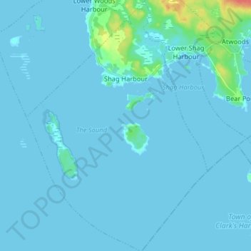
Nome: Mapa topográfico Shag Harbour, altitude, relevo.
Altitude média: 3 m
Altitude mínima: -1 m
Altitude máxima: 45 m
Outros mapas topográficos
Clique em um mapa para visualizar sua topografia, sua altitude e seu relevo.
East Sable River
Canada > Nova Scotia > Shelburne County
East Sable River, Municipality of the District of Shelburne, Shelburne County, Nova Scotia, B0T 1V0, Canada
Altitude média: 17 m
Clam Creek
Canada > Nova Scotia > Shelburne County > Cape Negro
Clam Creek, Cape Negro, Municipality of the District of Barrington, Shelburne County, Nova Scotia, B0W 1K0, Canada
Altitude média: 2 m
Shag Harbour Pond
Canada > Nova Scotia > Shelburne County > Lower Shag Harbour
Shag Harbour Pond, Lower Shag Harbour, Municipality of the District of Barrington, Shelburne County, Nova Scotia, B0W 3B0, Canada
Altitude média: 11 m
Sable River
Canada > Nova Scotia > Shelburne County
Sable River, Municipality of the District of Shelburne, Shelburne County, Nova Scotia, B0T 1J0, Canada
Altitude média: 50 m
Brook Islands
Canada > Nova Scotia > Shelburne County > Shag Harbour
Brook Islands, Shag Harbour, Municipality of the District of Barrington, Shelburne County, Nova Scotia, B0W 3B0, Canada
Altitude média: 9 m