
Mapa topográfico Manitou
Mapa interativo
Clique no mapa para exibir a altitude.
Sobre este mapa
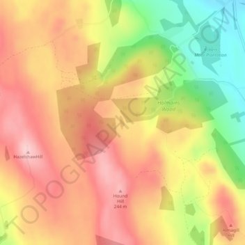
Nome: Mapa topográfico Manitou, altitude, relevo.
Local: Manitou, Dumfries and Galloway, Scotland, United Kingdom (55.07817 -3.44932 55.07971 -3.44828)
Altitude média: 167 m
Altitude mínima: 45 m
Altitude máxima: 251 m
Outros mapas topográficos
Clique em um mapa para visualizar sua topografia, sua altitude e seu relevo.
Langholm
United Kingdom > Scotland > Dumfries and Galloway
Langholm, Dumfries and Galloway, Scotland, DG13 0JQ, United Kingdom
Altitude média: 185 m
Annan
United Kingdom > Scotland > Dumfries and Galloway
Annan, Dumfries and Galloway, Scotland, DG12 5AW, United Kingdom
Altitude média: 26 m
Gatehouse of Fleet
United Kingdom > Scotland > Dumfries and Galloway
Gatehouse of Fleet, Dumfries and Galloway, Scotland, DG7 2HR, United Kingdom
Altitude média: 64 m