
Mapa topográfico Murcia
Mapa interativo
Clique no mapa para exibir a altitude.
Sobre este mapa
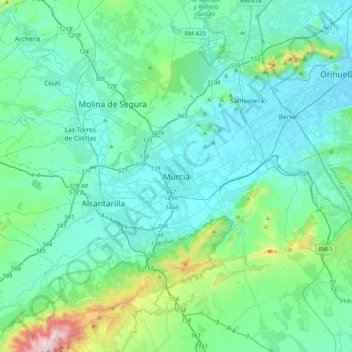
Nome: Mapa topográfico Murcia, altitude, relevo.
Altitude média: 169 m
Altitude mínima: 19 m
Altitude máxima: 1057 m
Murcia is located near the center of a low-lying fertile plain known as the huerta (orchard or vineyard) of Murcia. The Segura River and its right-hand tributary, the Guadalentín, run through the area. The city has an elevation of 43 metres (141 ft) above sea level and its municipality covers approximately 882 square kilometres (341 sq mi).