
Mapa topográfico Boulder
Clique no mapa para exibir a altitude.
Boulder
Boulder is located at the base of the foothills of the Rocky Mountains, at an elevation of 5,430 feet (1,655 m) above sea level. Boulder is 25 miles (40 km) northwest of the Colorado State Capitol in Denver. It is home of the main campus of the University of Colorado, the state's largest university.
Sobre este mapa
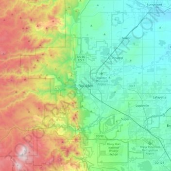
Nome: Mapa topográfico Boulder, altitude, relevo.
Local: Boulder, Boulder County, Colorado, 80306, United States (39.85499 -105.43055 40.17499 -105.11055)
Altitude média: 1977 m
Altitude mínima: 1495 m
Altitude máxima: 3187 m
Outros mapas topográficos
Clique em um mapa para visualizar sua topografia, sua altitude e seu relevo.
National Center for Atmospheric Research
United States > Colorado > Boulder County > Boulder
Altitude média: 1816 m