
Mapa topográfico Moosic
Mapa interativo
Clique no mapa para exibir a altitude.
Sobre este mapa
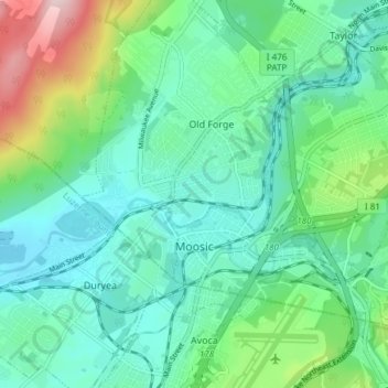
Nome: Mapa topográfico Moosic, altitude, relevo.
Altitude média: 246 m
Altitude mínima: 165 m
Altitude máxima: 505 m
Moosic is located in the Wyoming Valley of northeastern Pennsylvania. In terms of physiography, Moosic is part of the Ridge and Valley province of the Appalachian Mountains. Moosic is located at an elevation of 817 feet (249 m) above sea level. The major body of water flowing through the borough is the Lackawanna River, part of the Upper Susquehanna-Lackawanna Watershed. Moosic has a total area of 6.6 square miles (17 km2), of which 6.5 square miles (17 km2) is land and 0.1 square miles (0.26 km2) (1.52%) is water. Moosic has a humid continental climate (Köppen Dfa) with four distinct seasons. Summers are humid and warm, with an occasional heatwave. Winters are cold and snowy.