
Mapa topográfico Sumner Lake State Park
Mapa interativo
Clique no mapa para exibir a altitude.
Sumner Lake State Park
The park features a large 4,500-acre (18 km2) reservoir on the Pecos River, created in 1939 by the Sumner Dam of the United States Bureau of Reclamation. The reservoir is home to various fish species including largemouth bass, catfish, crappie and walleye. The park elevation is 4,300 feet (1,300 m) above sea level. With its campground, expansive views of the sky, and its distance from other cities, Sumner Lake State Park has a low level of light pollution, which makes the state park a great potential place for amateur astronomy.
Sobre este mapa
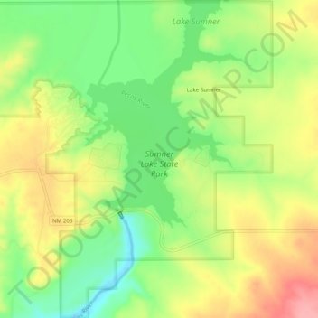
Nome: Mapa topográfico Sumner Lake State Park, altitude, relevo.
Altitude média: 1311 m
Altitude mínima: 1262 m
Altitude máxima: 1364 m
Outros mapas topográficos
Clique em um mapa para visualizar sua topografia, sua altitude e seu relevo.
Fort Sumner
United States > New Mexico > De Baca County
In the 1920s the Transcontinental Air Transport airline built an airfield in Fort Sumner as part of its coast-to-coast air passenger network, but the site was abandoned when the airline's ambitious plans collapsed in the Great Depression. The airfield was reopened by the United States Army Air Forces as a…
Altitude média: 1242 m