
Mapa topográfico Banggi Island
Mapa interativo
Clique no mapa para exibir a altitude.
Sobre este mapa
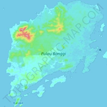
Nome: Mapa topográfico Banggi Island, altitude, relevo.
Local: Banggi Island, Kudat, Kudat Division, Sabah, Malaysia (7.10037 117.05402 7.36281 117.29496)
Altitude média: 21 m
Altitude mínima: 0 m
Altitude máxima: 487 m
Banggi Island (Malay: Pulau Banggi) is located within the Kudat Division of Sabah in Malaysia. With an area of 440.7 square kilometres, it is the largest island in Malaysia followed by Bruit Island, Langkawi Island and Penang Island. It is located off the northern coast of Sabah near Marudu Bay. The highest elevation on the island is Bukit Sinambung with height of 529 metres. As of 2016, it has an estimated population of 30,000. Banggi's largest settlement is Limbuak. In 2014, a new township was proposed to be built in the island. The island is also part of the gazetted area of Tun Mustapha Marine Park.
Outros mapas topográficos
Clique em um mapa para visualizar sua topografia, sua altitude e seu relevo.
Kg. Tinangol
Kg. Tinangol, Kudat, Kudat Division, Sabah, Malaysia
Altitude média: 75 m
The Tip of Borneo
The Tip of Borneo, Kudat, Kudat Division, Sabah, Malaysia
Altitude média: 3 m