
Mapa topográfico Genoa
Mapa interativo
Clique no mapa para exibir a altitude.
Sobre este mapa
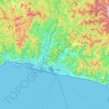
Nome: Mapa topográfico Genoa, altitude, relevo.
Local: Genoa, Liguria, Italy (44.37847 8.66574 44.51984 9.09558)
Altitude média: 333 m
Altitude mínima: -4 m
Altitude máxima: 1525 m
The city of Genoa covers an area of 243 square kilometres (94 sq mi) between the Ligurian Sea and the Apennine Mountains. The city stretches along the coast for about 30 kilometres (19 mi) from the neighbourhood of Voltri to Nervi, and for 10 kilometres (6.2 mi) from the coast to the north along the valleys Polcevera and Bisagno. The territory of Genoa is popularly divided into 5 main zones: the centre, the west, the east, the Polcevera and the Bisagno Valley. Although much of the city centre is located at a low elevation, the territory surrounding it is mountainous with undeveloped land usually being in steep terrain.
Outros mapas topográficos
Clique em um mapa para visualizar sua topografia, sua altitude e seu relevo.
Santo Stefano d'Aveto
Santo Stefano d'Aveto, Genoa, Liguria, Italy
Altitude média: 1166 m
Villetta Di Negro
Italy > Liguria > Genoa > Genoa
Villetta Di Negro, Genoa, Liguria, 16122, Italy
Altitude média: 53 m
Sestri Levante
Sestri Levante, Genoa, Liguria, 16039, Italy
Altitude média: 114 m